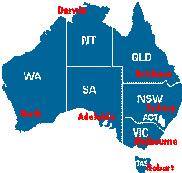
NSW ACT VIC SA NT QLD WA TAS
TOURS
Things to see and do in Australia.
(In a semi-logical order of distances)
Preliminary Draft.
Note: Archived site for historical purposes only. This was my first attempt at creating a “proper” website and dates from 2002.
Note: If you haven't got Internet Explorer 6 or Netscape 6 go get one now, they are all free and this page won't look the same without them.
Please email me any ideas/additions etc. If you're Australian, tell me what there is to do in your area. If you're not, let me know what you would like to do or see if you came here. Thanks.
NSW ACT VIC SA
NT QLD WA TAS
TOURS
Australia

Please note that this site is "Under Construction" indefinately and is not intended for public viewing. The information herein is not inteded to be disseminated in any way. Information has been copied from various sources and may be copyright. This page is for the sole purpose of personal study, for myself only.
Australia is a vast island continent situated south of Indonesia and Papua New Guinea between the Pacific and Indian oceans. The world's sixth largest country, Australia measures some 4000km (2500mi) east to west and 3200km (2000mi) north to south. Much of the interior of the country is flat, barren and extremely sparsely populated. The bulk of the population lives on the narrow, fertile eastern coastal plain and on the south-eastern coast. The continent-long Great Dividing Range runs north-south down the eastern seaboard, separating the coastal plain from the drier inland areas. The Great Barrier Reef lies between 50-300km (30-185mi) offshore and extends 2000km (1240mi) from the Torres Strait to Gladstone. Area: 2,966,152 sq miles (7,682,300 sq km)
In 1999, 4.3 million international visitors came to Australia.
Total arrivals in 2000 exceeded 4.9 million. Australias population
is about 19.5 million.
Australia welcomes overseas visitors. However, anyone who is not an Australian citizen needs a valid visa to enter and spend time in Australia. There are different visas for tourists, business people, sports people, students and others. All visas must be obtained before travelling. Electronic (and free) Visas are available to Americans and some other countries.
What to Pack:
Australian lifestyle is generally informal and the accepted norm is
to dress for comfort. We recommend you pack lightweight, comfortable
clothes and shoes while a sun hat, sun glasses and sun cream are must
have. If you're visiting during winter, leave space for a jacket or
sweater; and if you're planning a special occasion a more formal outfit
may be required. Australia's sunny climate makes for a great vacation
weather but sunburn is best avoided. Wear a shady hat and cover up
exposed skin with long sleeves or strong sunscreen. Wear factor 15+
[sun lotion] and try to avoid exposure during the hottest part of
the day-- from 10am to 3pm.
Climate:
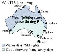
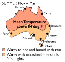
Australias winter months are from May to October, with July having
the lowest average temperature countrywide. Alpine areas are the coldest,
with temperatures averaging between 5°C (43°F) and -5°C
(20°F), while the tropics stay in the pluses, recording an average
of between 5°C (43°F) and 30°C (100°F).
The electrical current in Australia is 240/250 volt AC 50Hz. The Australian 3-pin power outlet is different so you will need an adaptor socket. If your appliances are 110v check if there is a 110/240v switch. If not, you will need a voltage converter.
Motoring:
International licences or current drivers' licences written in English
are accepted but restrictions may apply to drivers under 25 or over
75. Australians drive on the left hand side of the road.
Visitors to Australia generally do not have access to the tax-supported health system, and should obtain advice about appropriate health insurance. Visitors should acquaint themselves with Australia's customs, immigration and quarantine laws before travelling. The Australian Tourist Commision may be of interest.
Guide to Australia Visiting Australia About Australia Customs Immigration Quarantine Motoring Climate World Time Convertor Units Convertor Currency Convertor Maps Tourist Map Click for Australia Online Tour Guide Photo Tour
Australia's currency is the Australian Dollar. The most commonly accepted credit cards are American Express, Bankcard, Carte Blanche, Diners Club, MasterCard, Visa and their affiliates. Use may be restricted in smaller towns and country areas and small retail shops. Also, you should try and cash travelers checks at banks or larger hotels as it may be difficult elsewhere. ATM cards can be used in Australia at both ATMs (Automatic Teller Machines) and at participating retail locations, so long as they have been enabled for international access. Your ATM card must carry either the CIRRUS, PLUS or STAR international ATM mark or the Interlink or Maestro POS mark. Travelers should contact their bank at home for information on availability and service charges. Also, get the best exchange rates and find out where your credit cards will or won't be accepted. In addition, when traveling to an exotic location, trip insurance is always a good precaution.
Meals:
Budget: US$3-5
Mid-range: US$5-15
Top-end: US$15 and upwards
Lodging:
Budget: US$6-15
Mid-range: US$15-60
Top-end: US$60 and upwards
The biggest advantage of exchanging money with your ATM card is that
all cash withdrawals, regardless of size, are exchanged based on the
wholesale exchange rate which is usually reserved only for very large
interbank exchanges. This rate is often 2-5% better than what you
can get from exchanging traveler's checks at a local exchange counter.
In addition, local banks or money change bureaus will add on transaction
fees which can easily eat up another 2% of your money.
Your bank should be able to give you a listing of all ATMs available
on your network. CIRRUS users can also call (800) 424-7787 for a current
list of locations worldwide. (There's heaps in Australia, only
the most remote areas are without an ATM). The Cirrus network is associated
with Mastercard and Cirrus ATMs usually accept Mastercard for cash
advances and vice versa.
If you want to use your ATM card overseas, keep in mind that many
ATMs abroad, particularly in Europe, do not accept PINs that are longer
than four digits. If your PIN is longer, you can go to your local
bank and have it changed. If your PIN is based on letters rather than
numbers, translate the letters into numbers before leaving the country.
We found several ATMs that only had numbers on the keypad. Also, keep
in mind that most ATMs abroad will only let you access the primary
account on your ATM card.
Banks are open Monday to Thursday from 9.30am to 4.00pm and until 5.00pm on Fridays. Automatic tellers are available 24 hours a day in most areas.
Cirrus and PLUS ATMs overseas work pretty much like they work at home.
You will probably be charged the same transaction fee, if any, that
your bank charges you when using other bank ATMs. However, you should
check with your bank before using your ATM card at non-branch ATMs
or abroad. ATM transaction fees are becoming more commonplace and
increasingly surcharges are being imposed by both the customer's bank
and the ATM's owner as well. Some banks are reportedly charging as
much as $5 per transaction for the use of overseas ATMs, however,
most banks do have much more reasonable fees.
New South Wales

 New South Wales is in the south-east of the country and is the most
populous and heavily industrialized state in Australia with its capital
Sydney. It is Australia's largest state with a total area of 802 000
square kilometers (309 653 square miles) and a population of 6.5 million
people.
New South Wales is in the south-east of the country and is the most
populous and heavily industrialized state in Australia with its capital
Sydney. It is Australia's largest state with a total area of 802 000
square kilometers (309 653 square miles) and a population of 6.5 million
people.
New South Wales is the most varied of all states with four main zones:
The Seaboard and coastal lowlands which has over 1300 kilometers (807
miles) of coastline; the Tablelands formed by the Great Dividing Range
and comprising of an almost unbroken series of plateau varying in
width from 50 kilometers to 160 kilometers (30 miles to 100 miles)
(the Snowy Mountains region has the highest peak on the continent,
Mount Kosciusko, which is 2228 meters (7309 feet)); the Western slopes
which is a fertile region with the rivers flowing inland including
the Darling and Murray River which is 1900 kilometres (1180 miles)
long; and the Western plains comprising of almost two thirds of the
state. This area has poor rainfall and limited river water thus causing
the fertile soil to fall short of its potential.
New South Wales' climate is a temperate climate and is generally free
of extreme heat and cold, however the Snowy Mountains experience snow
and winter frosts over long periods of time. If your desire is to
freeze to death in Australia, you could do worse than the Snowy Mountains
in Winter.
Photo Tour | Tourism NSW | Visit NSW |
Sydney is where most International
tourists fly
into, especially from America. Most other cities require a stop-off
enroute. Other international airports include Melbourne and Brisbane,
followed by Perth, Adelaide, Hobart, Darwin and Cairns.
Population 4 million.
June and July night temperatures are rarely below 55°F (10°C)
Opera House
Harbour Bridge
Ferries
on the Harbour
Beaches
.
Blue Mountains
Bush Walking Info
Sydney | International Airport | Opera House | Harbour Ferries | Blue Mountains | Blue Mountains | Bush Walking Information
The Blue Mountains, only 90 minutes drive from Sydney, is one of the most spectacular wilderness parks in Australia. These richly forested hills offer cliff-top views across gum tree valleys and craggy outcrops, superb bushwalking, scenic drives and adventure activities, as well as historic towns built from timber and stone.
The Snowy Mountains boast trout-filled mountain streams, silent bushland, breathtaking vistas, rugged gorges, alpine lakes and fresh mountain air. In winter, the slopes are covered with snow - perfect for downhill and cross-country skiers. At other times wildflowers cloak the high plains.
The mighty Murray River travels over 2500 kilometres (1553 miles) through three states, ending its journey in South Australia. Enjoy wonderful scenery, cruise on a paddle steamer, relive the history of river towns, visit boutique wineries and experience the incredible wildlife of the river.
The extraordinary opal mining town of Lightning Ridge is a place of tall tales, drills and hoists, and true outback characters. See a castle built by hand, take a dip in a hot artesian bath beneath the stars, meet the locals in a 'wild west' pub, and tour an underground mine or two.
The Mount Warning Shield Volcano forms a spectacular mountainous backdrop to the entire region, with its peak receiving Australia's first rays of sunshine. Walk through tropical rainforest thick with life at the World Heritage listed Mount Warning, Nightcap and Border Ranges national parks.
The World Heritage listed Dorrigo National Park is one of the best rainforest areas in Australia. The elevated Skywalk offers a bird's-eye view of the forest while ground level walks meander through the thick vegetation as tropical birds flutter by.
Australian Capital Territory

 The
Australian Government took possession of 2357 square kilometers (910
square miles) of land from New South Wales in 1911 to form the Australian
Capital Territory as the site for the Australia National Capital.
That capital, Canberra, lies between Sydney, 307 kilometers (190 miles)
north-east and Melbourne 655 kilometers (406 miles) south-west. The
name Canberra came from the Aboriginal word meaning 'meeting place'.
Population 314,200
The
Australian Government took possession of 2357 square kilometers (910
square miles) of land from New South Wales in 1911 to form the Australian
Capital Territory as the site for the Australia National Capital.
That capital, Canberra, lies between Sydney, 307 kilometers (190 miles)
north-east and Melbourne 655 kilometers (406 miles) south-west. The
name Canberra came from the Aboriginal word meaning 'meeting place'.
Population 314,200
none
Canberra is a beautiful young city originally planned by Walter Burley Griffin in 1911 when he won an international competition to plan a city. On 12 March 1913, Canberra was officially named with the laying of the foundation stone on Capital Hill, now the site of Parliament House. The city of Canberra lies approximately 190 miles (300 kilometres) southeast of Sydney and readily linked by road, rail and air services. Winter can be cold, it does very rarely snow. Population: 309,500.
On the lower slopes of Black Mountain, behind the Australian National University, the beautiful 50 hectare (123 acre) botanic gardens are devoted to Australian flora. There are educational walks, including one among plants used by Aborigines. A highlight is the rainforest area, achieved in this dry climate with a misting system, while the eucalypt lawn has 600 species of this ubiquitous Australian tree.
Located in the south-western corner of New South Wales, the Snowy Mountains are the highest section of Australia's Great Dividing Range. Kosciusko National Park covers most of the mountains. It's NSW's largest park (6900 sq km/2690 sq mi), stretching from the Victorian border to the ACT. It includes all of the state's ski resorts, rugged alpine scenery, caves, glacial lakes and forests. Although its renowned as a winter playground, the park is also popular with bushwalkers in summer, when there are marvellous alpine wildflowers. The ski resorts include Thredbo, Perisher Valley, Smiggins Hole and Mt Blue Cow. Mt Kosciusko is the highest peak at 2228m (7308ft). The main town in the region is Jindabyne, situated just outside the park boundary on the edge of a beautiful lake.
Victoria

 Victoria lies in the southeast corner of Australia. The capital of
Victoria is Melbourne. It has a population of 4.8 million of which
3.1 million live in Melbourne. It covers an area of 227,600 square
kilometers (87876 square miles) which is about the same size as England,
Wales and Scotland combined. Victoria however is approximately only
3% of Australia's total land mass but has 1/4 of the population. Victoria
has 1,800 kilometer coastline which borders on Bass Strait, which
separates the mainland from Tasmania. About 35% of Victoria is covered
by natural forest while mountainous regions are found in the north-east,
where during the winter snow settles upon them. The highest peaks
in these mountains are Mount Bogong (1986 meters/6515 feet) and Mount
Feathertop (1922 meters/6305 feet).
Victoria lies in the southeast corner of Australia. The capital of
Victoria is Melbourne. It has a population of 4.8 million of which
3.1 million live in Melbourne. It covers an area of 227,600 square
kilometers (87876 square miles) which is about the same size as England,
Wales and Scotland combined. Victoria however is approximately only
3% of Australia's total land mass but has 1/4 of the population. Victoria
has 1,800 kilometer coastline which borders on Bass Strait, which
separates the mainland from Tasmania. About 35% of Victoria is covered
by natural forest while mountainous regions are found in the north-east,
where during the winter snow settles upon them. The highest peaks
in these mountains are Mount Bogong (1986 meters/6515 feet) and Mount
Feathertop (1922 meters/6305 feet).
The daily temperatures range from 14 - 23 °C (57 - 73 °F)
in the coastal area during the summer months and between 7 - 14 °C
(44 - 73 °F) during the winter.
Warning: Contains Melbournites.
none
The cool hills of the Dandenong Ranges offer a delightful world of Devonshire teas, antique shops, craft stores and historic houses. If you love nature you'll find heaven here - look out for famous gardens, nature walks through forests and fern gullies, bonsai and bulb farms, and tumbling waterfalls. The Dandenong Ranges are perfect for a nature walk.
Dramatic and hauntingly beautiful, the massive sandstone ranges of the Grampians National Park are one of Victoria's most popular attractions. There's an abundance of wildlife, including emus, kangaroos, echidnas, koalas, and several species of wallaby, as well as almost 200 species of birds. With around 160 kilometres of maintained walking tracks, the Grampians National Park is perfect for a scenic stroll or a challenging multi-day adventure.
Fern gullies, rainforest, woodland and heath - as well as spectacular coastline between Apollo Bay and Princetown - make this park a national treasure. Swamp wallabies and ring-tailed possums are common, as are king parrots, owls and the grey goshawk. The park offers camping, walking, fishing, canoeing and surfing.
Here, the ocean foams against cliffs and dramatic rock sculptures, such as the Twelve Apostles rock pillars, the Grotto, the Blowhole, and London Bridge, which collapsed in 1990, stranding some surprised tourists on the far end.
Ski on trails between gum trees, right to your ski lodge door. The Victorian high country is famous for its downhill and cross-country skiing from June to October. World-class resorts operate from Falls Creek, Mt Hotham, Mt Buffalo, Mt Buller and Mt Stirling, all situated around or in the stunning Alpine National Park
As well as one of Australia's best known wildlife havens, Phillip Island also offers world-class interactive visitor centres, and even a Grand Prix Circuit hosting world championship motorcycle events. Phillip Island is home to the country's largest colony of Australian fur seals, numbering 12-18,000.
Victoria's most popular national park, Wilsons Promontory occupies a rugged peninsula jutting out into Bass Strait, featuring a magnificent coastline of steep cliffs and headlands plunging to white beaches and sheltered bays. Forested slopes, fern glades, sand dunes, and lakes make for perfect camping, walking, bird watching and swimming.
South Australia

 South
Australia is classed as the state in south central Australia along
the Indian Ocean. It covers an area of 984,377 square kilometres (380,070
square miles). The capital of South Australia is Adelaide and its
known as the City of Churches. South Australia became a British colony
in 1836 and joined the Commonwealth of Australia in 1901. The state's
population is 1.5 million and most of those reside in the fertile
coastal areas and in the valley of the Murray River which is the only
navigable river and drains about one seventh of Australia then enters
the sea in South Australia. The first recorded sighting of the South
Australian coast was in 1627 when a Dutch ship examined the coastline.
South
Australia is classed as the state in south central Australia along
the Indian Ocean. It covers an area of 984,377 square kilometres (380,070
square miles). The capital of South Australia is Adelaide and its
known as the City of Churches. South Australia became a British colony
in 1836 and joined the Commonwealth of Australia in 1901. The state's
population is 1.5 million and most of those reside in the fertile
coastal areas and in the valley of the Murray River which is the only
navigable river and drains about one seventh of Australia then enters
the sea in South Australia. The first recorded sighting of the South
Australian coast was in 1627 when a Dutch ship examined the coastline.
The terrain consists largely of dry wasteland, with several low mountain
ranges in which the most important mountains are the Mt Lofty-Flinders
Ranges system which extends north about 800 kilometers from Cape Jervis
to the northern end of Lake Torrens and salt lakes. Its principal
industries and export are wheat, wine and wool. More than half the
nations wines are produced here.
South Australia has boundaries with other states on the west, east,
north and the south is flanked by the Southern Ocean. South Australia's
temperate range is 29°C (84°F) in January and 15°C (59°F)
July.
When the early colonists began building Adelaide they built with stone,
constructing a solid, dignified city that is civilised and calm in
a way that no other Australian state capital can match. The solidity
goes further than architecture, for Adelaide was once regarded as
a city of wowsers (read: puritan spoilsports) and was renowned chiefly
for its disproportionately large number of churches. These days, the
churches are outnumbered by pubs and nightclubs, and there is no denying
that the city has a superb setting - the centre is surrounded by green
parkland, and the metropolitan area is bound by the hills of the Mt
Lofty Ranges and the waters of the Gulf St Vincent.
Population: 1,085,000
Kangaroo Island is a great place to visit! The third largest island off the coast of Australia, Kangaroo Island is one of the few places in the world where huge expanses of natural bushland still exist - and that means that wildlife populations have the opportunity to.
A mere 40 minutes off mainland South Australia, Kangaroo Island is the one of the most unique, unspoilt wildernesses in Australia.
The Island is home to numerous species of wildlife; many of the animals are unique to Kangaroo Island and uncommon or even extinct on the mainland. National and Conservation Parks cover about one third of the Island, from which you can enjoy the sheltered beaches and rugged coastline of Kangaroo Island.
Apart from its spectacular natural beauty, Kangaroo Island produces gourmet food and has a world-class reputation for great hospitality.
The Island offers an endless list of recreational activities, including fishing, surfing, swimming and diving, bushwalking, climbing, sightseeing, boating and horse riding, all in natural environments with clean, fresh air.
Kangaroo Island | Tour Kangaroo Island | Map | Island Links | Island Ferry
Ghan
Coober Pedy
Northern Territory

 The
Northern Territory covers about one sixth of the Australian continent
with an area of 1.35 million square kilometers (521,237 square miles)
including 6200 kilometers (3852 miles)of coast line. This is equal
to the combined areas of France, Italy and Spain. The population is
197,600 people and they live mainly in the centers of Darwin, Katherine,
Tennant Creek and Alice Springs, however despite its size, the Northern
Territory represents less than two percent of Australia's population.
The
Northern Territory covers about one sixth of the Australian continent
with an area of 1.35 million square kilometers (521,237 square miles)
including 6200 kilometers (3852 miles)of coast line. This is equal
to the combined areas of France, Italy and Spain. The population is
197,600 people and they live mainly in the centers of Darwin, Katherine,
Tennant Creek and Alice Springs, however despite its size, the Northern
Territory represents less than two percent of Australia's population.
The northern quarter of the state is known as the "Top End"
and has a distinct region of savannah wood-lands and pockets of rain-forests
and the capital Darwin is situated here. The Arnhem Land plateau which
is in the north-east, rises abruptly from the plain and continues
to the coast of the Gulf of Carpentaria. In the central Australia,
the Territory is crossed by the east-west ridges of the Macdonnell
Ranges, with heights reaching more than 600 meters (1968 feet). The
well known monolith, Uluru formally known as Ayers Rock, is 348 meters
(1141 feet) high and is near the south-west corner of the Territory.
Whereas much of the southern three quarters of the Territory consists
of desert and semi arid plain.
The Northern Territory has two main centers, Darwin and Alice Springs,
and each of these have totally different climates. Darwin's temperature
remains almost constant throughout the year with the daily average
maximum being 32°C (90°F) whereas Alice Springs experiences
a desert summer with temperatures in the range of 36°C (97°F)
during the day and in winter the nights range in the area of 2°C
(36°F). The rainfall also varies between the center and in the
north, monsoonal influences produce two definite seasons known as
"the wet" ( October to April ) and "the dry" (
May to September ). During the wet season the coast is subject to
tropical cyclones ( hurricanes or typhoon's ).
The Alice (population 27,000) is a pleasant modern town, smack in the middle of Australia, built on the banks of the usually-dry Todd River. At first appearance it's so civilised that it can be a real disappointment to those expecting saloons on every corner and colourful bush characters, but stick around and explore the area and you'll begin to appreciate the flavour of this desert community. The town was founded as a staging point for the overland telegraph line in 1870, although its growth has occurred only in the last 30 years. The road south to Adelaide was only fully sealed in 1987
To the west of Ayers Rock lies Mt Olga/Kata Tjuta, a collection of weathered red domes, the tallest of which stands 200 metres taller than Ayers Rock. Many people who come here are surprised by the beauty of the lesser known Olgas, many believing they hold greater charm than the Rock.
Uluru, also known as Ayers Rock, is the world's biggest monolith. It is 9.4 km (5.8 mi ) if you walk around it, and about 345 metres (1131 feet) high if you climb it (and is thought to be the tip of a mountain which extends kilometres below the surface). It's 3.6km (2.2 mi) long, 2 km (1.2 mi) wide, and is roughly oval in shape. It's made of arkosic sandstone, and is renowned for the way it changes colour in the light and is particularly spectacular at sunrise and sunset.
People will tell you that the interior of Australia - that loooonnnngggg
stretch of land between the southern tip of the mainland and Darwin
at the Top End - is one of the most barren and abandoned pieces of
real estate on God's green earth. And they're right - it is.
Visit the underground mining town of Cooper Pedy (the name is Aboriginal
for 'white fella's hole in the ground,' which pretty much sums it
up) and fossick for opals, take a swim in the crystal clear waters
of Mataranka Springs, have a few rest days in Alice Springs, then
visit Uluru or camp in the vicinity of the stunning gorges in the
McDonnell Ranges. If you're looking to get away from the hurly-burly
of big city life there's no better place to do it than in the Central
Deserts. Get a 4WD and head out into the empty wilderness, sleeping
at night under the Southern Cross and the vast ocean of stars.
Darwin, the 'capital' of Northern Australia is closer to Jakarta than it is to Sydney, and closer to Singapore than it is to Melbourne, so it's no surprise that it looks outward to Asia as much as it looks inland to the rest of Australia. This proximity and familiarity with Australia's northern neighbours is reflected in the town's relaxed, cosmopolitan, tropical atmosphere.
Kakadu is one of the world's special places. From the 'stone country' of the spectacular Arnhem plateau and escarpment to the verdant monsoon forests and wetlands, this place has a history and presence like nowhere else on earth. Kakadu National Park is one of the natural marvels of Australia. It encompasses a variety of superb landscapes, swarms with wildlife and has some of Australia's best Aboriginal rock art. The vast park is 153km (95mi) by road from Darwin, in the Northern Territory, and stretches more than 200km (125mi) north to south and 100km (60mi) east to west. It is on the World Heritage list both for its natural and cultural importance. Part of the park is Aboriginal land and there are three contentious uranium mining leases operating in the east.
Queensland

 It
is Australia's second largest state covering 1,722,000 square kilometers
(107,384 square miles) and the third most populous state with more
than 3.6 million inhabitants - 17% of the nations people. It is two
and a half times the size of Texas or seven times the size of the
United Kingdom and more than half of the state is above the Tropic
of Capricorn. It borders with New South Wales, Northern Territory
and South Australia. It is bounded by the Gulf of Carpentaria, Torres
Strait and the Coral Sea in the north, and the South Pacific Ocean
in the east. The total coastline is 7400 kilometers (4600 miles).
It
is Australia's second largest state covering 1,722,000 square kilometers
(107,384 square miles) and the third most populous state with more
than 3.6 million inhabitants - 17% of the nations people. It is two
and a half times the size of Texas or seven times the size of the
United Kingdom and more than half of the state is above the Tropic
of Capricorn. It borders with New South Wales, Northern Territory
and South Australia. It is bounded by the Gulf of Carpentaria, Torres
Strait and the Coral Sea in the north, and the South Pacific Ocean
in the east. The total coastline is 7400 kilometers (4600 miles).
Queensland is a state of great plains which merge into high country
to the east and north-west. The country falls gradually to meet the
coastal plain which reaches the Gulf of Carpentaria in the north.
Rugged uplands region which is rich in minerals are in the far north-west
and in the east the country rises towards the Great Dividing Range,
which runs from the southern border to the northern tip of the state.
East of this range the country drops seaward in a jumble of ranges
separated by lowlands. This structure is continued in a chain of mountainous
offshore islands sitting on the continental shelf. The Great Barrier
Reef is situated beyond this and has coral formations stretching for
about 2000 kilometers (1243 miles).
Cairns is the tourist 'capital' of the Far North and one of Australia's top travellers' destinations. Not long ago, it was just a sleepy tropical backwater. Unfortunately, much of its allure and tropical languor has vanished amid the rapid growth of tourist infrastructure, but it is still one of the best bases for exploring the riches of Queensland. From Cairns, you can arrange trips to the Great Barrier Reef, Green Island and Fitzroy Island, the beautiful Atherton Tableland, the market town of Kuranda, the string of enchanting beaches stretching 50km (30mi) north to Port Douglas, and the spectacular rainforest and coastal scenery of Cape Tribulation and the Daintree River.
Maps |
One of Australia's greatest assets is the magnificent reef which runs along virtually the entire coast of Queensland. Considered one of the world's natural wonders, it is the most extensive reef system and the biggest structure made by living organisms on earth. In the north, the reef is virtually continuous and is located only 50km (30mi) from the shore. In the south, individual reefs are more common, and in some places up to 300km (190mi) offshore. Hundreds of islands dot the reef area. About 20 of them have resort facilities, but it's possible to camp on many others.
Visitors Bureau | Marine parks Authority | Island Resorts | Whitsundays | Discovery Coast | Green Island | Fitzroy Island
Reef and rainforest touch in this region of World Heritage protected
beauty. The Daintree River winds gently through tangled woodland through
jungle homes of unique birds, pythons and crocodiles, north to Cape
Tribulation, a spectacular national park.
none
Vibrant Townsville, 1,359 kilometres north of Brisbane, packs heaps
of experiences into one buzzing, sun-bathed city. Part of the 'dry
tropics,' the city offers a lively nightlife and restaurants and the
quieter pleasures of beaches, access to the Great Barrier Reef, islands
and national parks.
Townsville is an ideal access point for the Great Barrier Reef, which
stretches 230,000 square kilometres off the Queensland coast. Dive
companies and cruises offer expeditions to the reef from Townsville
and also from its northerly seaside neighbours.
Noosa, crown jewel of the Sunshine Coast, is nestled between national park and blue sea. A surfer's delight, its restaurants in bush and sea view settings offer fresh, sophisticated cuisine, and its trendy village centre entices with boutiques and cafes.
Brisbane.
The Gold Coast dares you to try everything it offers. Mingle with dolphins and polar bears at world-class theme parks, party on at nightclubs, dig your toes into fine white sand, ride sparkling waves, visit an island, and explore the lush, subtropical hinterland. The Gold Coast has 70 kilometres of coastline and 446 kilometres of canals and tidal rivers. Southport's Broadwater and South Moreton Bay make Australia's largest expanse of calm water, and you can swim and surf safely all year at 35 patrolled beaches.
Western Australia

 Western
Australia is the largest of the states. Perth, the capital of Western
Australia enjoys the best climate of any Australian capital with a
mean temp of 23.5°C (74.5°F) in the hottest month, February
and a mean temp of 13°C (55.5°F) in the coldest month of July.
Western
Australia is the largest of the states. Perth, the capital of Western
Australia enjoys the best climate of any Australian capital with a
mean temp of 23.5°C (74.5°F) in the hottest month, February
and a mean temp of 13°C (55.5°F) in the coldest month of July.
The total population of Western Australia is 1,909,800 in which the
majority live in and around Perth, approx 1,193,100.
Perth
Just a short ferry or plane trip from Perth. Visit for the string of sugar-white beaches and emerald bays, and to see quokkas, small marsupials common to the island. You can surf, dive, snorkel, or enjoy a swim in sheltered coves.
A vibrant port city rich in heritage buildings and maritime history. Fremantle is the best-preserved example in the world of a 19th century port streetscape, featuring heritage-listed buildings, and housing museums, art galleries and shops.
Just east of Perth, offers waterfalls, forests, national parks, golf, galleries, and fine cuisine. Also excellent bushwalking, especially during wildflower season. Nearby, the Swan Valley's award-winning wineries offer good food and tastings.
South of Perth, is an aquatic playground. From the sheltered water of Cockburn Sound to open ocean in Warnbro Sound, you can swim, surf, snorkel, sail, fish, and catch crabs. Safe beaches for children, ample jetties for fishing, and stores galore for shoppers.
The forests of the South-West are one of the state's most treasured natural assets. Below towering eucalyptus forests lie waterfalls, rivers, lakes and peppermint woodlands
Fitzgerald River National Park is renowned for its spectacular scenery and flora, which supports a number of threatened animals. More than 1,800 beautiful and bizarre species of flowering plants, as well as lichens, mosses and fungi, have been recorded - including 62 species found nowhere else
Covering nearly one third of Western Australia, the Goldfields is a land of contrast. You'll find gold-rush frontier towns like Kalgoorlie, and other towns rich in pioneering history. Kalgoorlie is pleasant and welcoming, with lovely architecture, many bars and nostalgic hotels laced with wrought-iron verandas. It is close to the Super Pit, the world's largest open-cut goldmine. Then there's the spectacular coastal landscape of Esperance and the unique and haunting Nullarbor Plain.
none
The Pilbara is an ancient land where sheer gorges and steep chasms rise out from the desert, while the Dampier Archipelago is a paradise of sheltered bays and islands. Look out for whales and turtles, Aboriginal rock engravings, and mountains of iron ore.
The huge, arid Gibson Desert in Western Australia's vast interior is hard country. Water is scarce, but still there's life here. Kangaroos and tiny marsupials eke out a living, while snakes and lizards leave trails and footprints behind in the red sand that Australia is so famous for.
The wild and remote Kimberley is one of the world's last great wilderness areas, with vast horizons, ancient gorges, weird rock formations, welcoming rock pools and golden beaches that will create lasting memories. A place of immense beauty and diverse climates, the Kimberley is like nothing else on earth.
Broome simply oozes with colour. It's Western Australia's secret getaway - right on the doorstep of the Indian Ocean and the gateway to Australia's last frontier of pristine wilderness - the Kimberley.
Tasmania

 Tasmania
is the smallest of Australia's six states and is an island lying to
the south of the south-east corner of the mainland. It is also second
oldest Australian colony. The smaller islands that surround Tasmania
are King, Flinders and Bruny Islands and these are part of the total
area of Tasmania which is 65,331 square kilometers (25224 square miles).
It has a heart-shape to it and is about the same size as Ireland.
The Bass Strait separates Tasmania from mainland Australia.
Tasmania
is the smallest of Australia's six states and is an island lying to
the south of the south-east corner of the mainland. It is also second
oldest Australian colony. The smaller islands that surround Tasmania
are King, Flinders and Bruny Islands and these are part of the total
area of Tasmania which is 65,331 square kilometers (25224 square miles).
It has a heart-shape to it and is about the same size as Ireland.
The Bass Strait separates Tasmania from mainland Australia.
Approximately 40% of Tasmania's 470,300 people live in and around
Hobart and the rest divided between Devonport, Burnie and Launceston
areas.
Tasmania is predominately mountains, none of which reach a height
of more than 1500 meters (16145 feet). The climate is a temperate
climate, warm in the summer months with an average temperature of
21°C (70°F) to snow in the mountains during the winter months
and an average of 12°C (54°F). The annual rain differs from
3600 mm (142 inches) in the west and 500mm (20 inches) in the east.
One of Tasmania's top attractions, Cradle Mountain offers bushwalks over grass plains, past lakes filled with trout, and majestic moss forests and stands of native pine. Craggy mountain ridges, pristine wilderness, hoards of scampering marsupials and delightful accommodation make for an essential stop-over.
Craggy pink granite peaks, spectacular white beaches, turquoise ocean, wetlands, heath lands, coastal dunes and swathes of eucalyptus forest all make Freycinet National Park one of Tasmania's most stunning.
Port Arthur on the Tasman Peninsula is one of Australia's prettiest harbours and the site of a former penal colony for reoffending convicts. Tasmania's number one tourist destination, the Port Arthur Historic Site houses the haunting remains of prison buildings and a fascinating museum.
The Franklin-Gordon Wild Rivers National Park lies in the heart of the Tasmanian Wilderness World Heritage area. Here are dramatic mountain peaks, beautiful rainforest, river valleys, spectacular gorges. The park is famous for the wild and pristine rivers that twist their way through the wilderness.
Temporary
!!
UNDER CONSTRUCTION !!
http://www.find-our-community.net/region/Australasia/Australia_map.htm
the Cathedral Ranges national park in Victoria
Portsea backbeach on the end of the mornington peninsula
sorrento rockpools
london bridge (sorrento)
crocodiles
About state Population figures
S.I. to Imperial conversion: I have attempted to convert S.I. figures to imperial (United States) where appropriate. This has been done in an approximate way, with the resulting conversion usually rounded to the nearest whole value.